Photophobic wrote: if anyone can attest to the "road" on that side it might make for better guesses too since my pavement to campground on the Ice Caves side was about 3 times longer than I expected.
Paul,
If you come down Idaho 95, google maps will lead you to Minidoka via Idaho 24. Cross the railroad tracks right after Idaho 24 turns south and stay to the left.
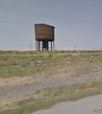
You will see the big water tower on the north side by the rail road tracks.
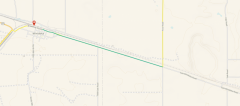
From the water tower follow the road east for 2.08 miles to the turn-off for Arco road (its gravel) and turn left heading north. Marked in green on the map below
Cream Can junction is 14.7 miles on Arco Rd. and the junction is marked. At the junction turn west you will be able to spot the camp on the south side of the road about 0.4 miles down the road.
Edit May 17. 2021
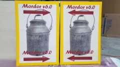
Cream Can Junction is in Google maps.
Made some signs to put up in critical spots
Hopefully that will help.
See you all in camp


